Why Porcupine Mountains a.k.a. the Porkies?
60,000 acres of rugged Upper Peninsula wilderness – the iconic Lake of the Clouds scenic overlook which only needs 350ft of walk to get to, waterfalls, bluffs, ancient forest with a magical foliage during fall color, dozens of hiking and biking trails, less crowded Lake Superior beaches; no wonder Porcupine has been named as the Best State Park in the country in many awards.

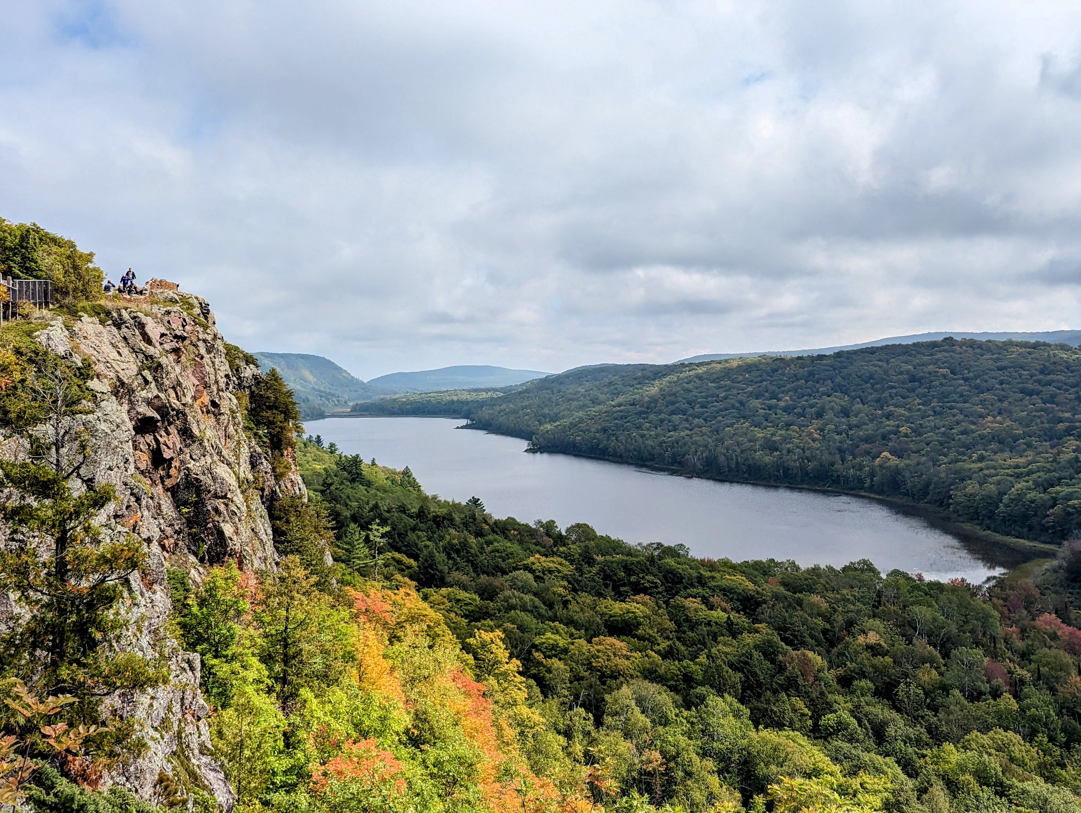
The heavenly ‘Lake of the Clouds’ at The Porkies

Soul enriching view in fall, courtesy Jonathan
Road Trip From Chicago
Chicago to Porcupine Mountains is about 400 miles and takes around 7 hours.
Once we headed into Michigan, the rolling countryside hills made the drive really charming.

One of many scenic landscapes, as seen on the way
The last 100 miles or so, the true upper peninsula wilderness took hold – scenic but desolate roads…

Hardly a car or a human being in sight for miles.

We meandered around the majestic Lake Superior, in the last few miles on the way to the Porcupine Mountains.

It was tempting to just stop the car and jump right in to the colossal lake.

And finally, there it was..

Tip: Plan your rest stops in advance, there were long stretches of drive without the typical on-the-road fast food options.
Visitor Center
When you visit such a large park, a jaunt to the Visitor Center is a must to know about what to visit!

An eponymous ‘Wilderness’ Visitor Center sign greeted us..

There is a small exhibition area with informational props, a gift shop and some very kind park rangers inside the center. We were patiently advised to visit 3 most vendible areas of the coveted park – Lake of the Clouds Scenic points, Summit Peak Tower (highest point of the park) and Presque Isle River Area. We covered them in the same order.
Visit the visitor center virtually here.
Tip: It took us till evening to cover aforementioned areas and we just had adults in the group. So, please plan accordingly.

Porcupine Mountains Map, Courtesy DNR MI
Lake of the Clouds
We parked the car at Lake of the Clouds scenic area and headed up. There are 3 scenic overlooks.
 A gentle 5-minute stroll led us to one of most splendid natural sights I have ever seen.

We could only dream how this would look in a couple of weeks under the veil of the fall foliage.
Another view of the unsullied Lake of the Clouds
Even the boardwalk connecting the several scenic overlooks was basking in the pre-fall glory.

We hiked for about an hour on both Big Carp River and the Escarpment trails, hoping (and at the same time not hoping) to see the Black Bear but there weren’t any.

Summit Peak Observation Tower
Our next stop was the Summit Peak Tower, the highest point of the park.
We hiked for about 1.5 miles to get to the top since they had closed off the portion of the road, it is a half-mile hike usually.

The hike had a natural surface with a little elevation.

A boardwalk accosted us in the last few stretches before the 40-ft tower.

And once atop the tower, we were awarded with the unrestricted views of the old-growth forest.

We hung around for a few minutes, gazing at the clouds whizzing by.

Presque Isle River Area
Presque Isle area is at the western tip of the park. Porcupine is so gigantic that it will take you about an hour to get to Presque area from the Lake of the Clouds.
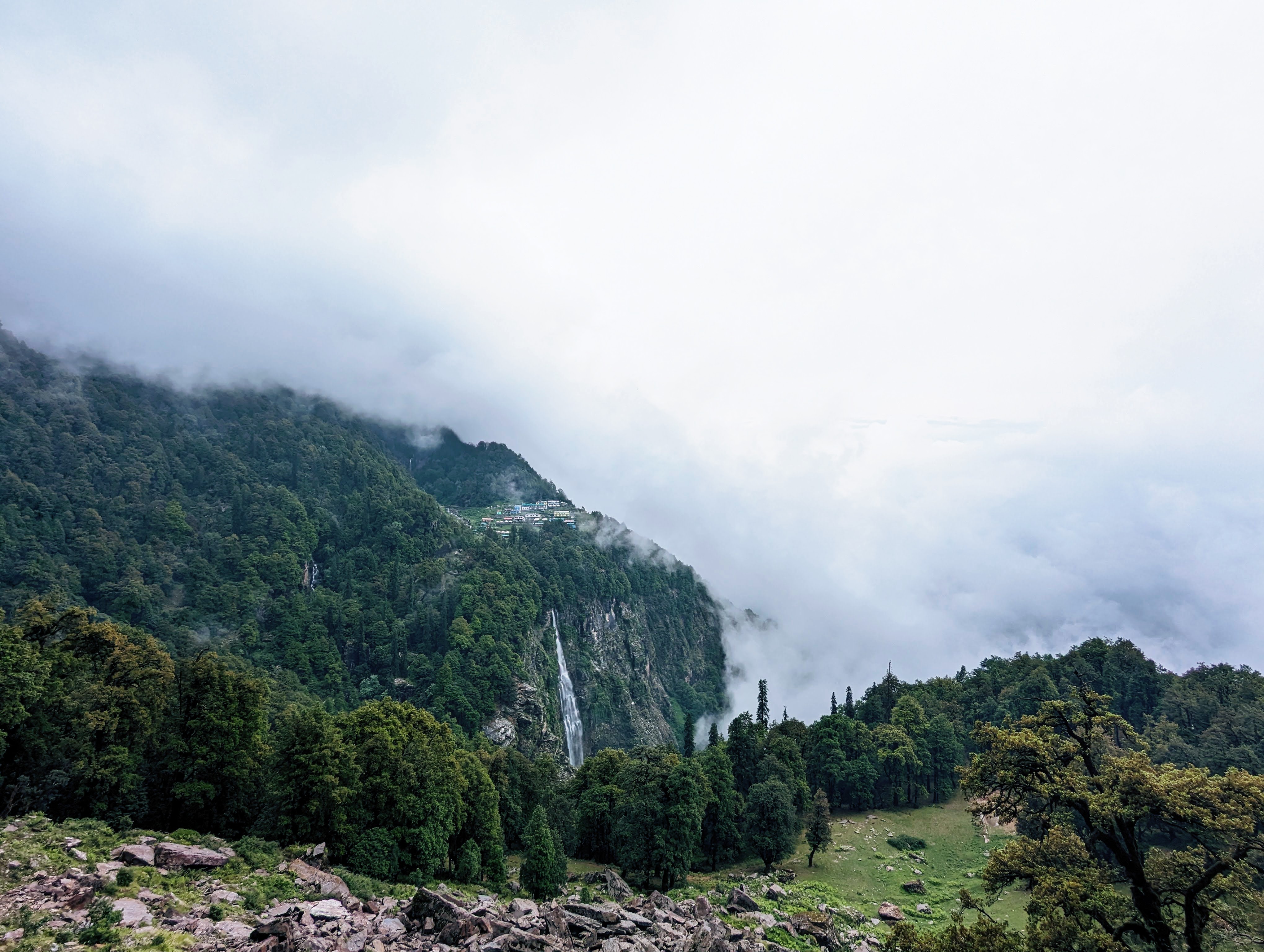
Presque Isle boasts of 3 waterfalls on the Presque River, which flows through the park – Manido, Nawadaha, and Manabezho falls; we chose to visit Nawadaha Falls, as that was the nearest.

The hike was effortless as we walked on a natural flat surface under a dense canopy of trees.

And the waterfall thoroughly exceeded our expectations – a 15-ft drop and extremely wide 100-ft crest made it look majestic.

The waterfall brink basked under the afternoon sun.

The gushing waterfall compensated for the warm summer sun.
Lake Superior
Our last stop was the Lake Superior beach at the northern edge of the Presque Isle (check the map to get the directions).
We ambled along for a few minutes on a natural trail full of shade.

There were some warning signs along the way, considering the cliffs, boardwalk and the bridge to cross the picturesque Presque river.

Presque river, when it was not roaring with gushing waterfalls, looked so serene.

One of the many warning signs..

Hit the beach, finally!

What good is a rocky beach, if you are not going to make a tall cairn!

And then destroy it…
Beware of the crabs!

The Cottage
Couple of hours of drive and reached just in time to gaze at the fleeing sun from our cottage dock.

With a resolution to visit Porcupine in the fall season embossed in our hearts, we welcomed the eventide.
Noteworthy Mentions
In terms of scenic roads – 107th Engineers Memorial Highway, running along the Lake Superior shoreline, and South Boundary Road have splendid views.

So Long, Porcupine Mountains

Leave a Reply